thesis research & studio
completed under advisement of:
peter wheelwright
c. brooke carter silber
final slides
compendium
bibliography
abstract
The introduction of the Common Lands grid through the 1811 Commissioner’s Plan for the City abstracted a three-dimensional landscape into a two-dimensional territory, disassociating the development of Manhattan from its ecological contexts.
As a result, the “manifest destiny” of the City, northwards, since 1811 has disseminated the image of an invariant, concrete public realm with a tendency to stagnate the rich phenomenological ecology engendered by the interaction of urban form and temporal light.
Today, West 13th Street stands as the “frontier”[1] edge between two opposing organizational schema: the topologically sensitive farms to the south border the orthographic “wilderness” to the north.
Mining the historical and geographical past of Manhattan at this frontier reveals an alternative methodology for future urban development that better utilizes landscape and diurnal light to impart meaning[2] into New York’s public realm.
introduction

The foundational research for this thesis studio project began as a search for the presence of environmental light within urban form, necessitating analysis of both “natural” and “constructed” contexts. The term “landscape” was thus split into two, borrowing from the earth:world dichotomy established by Martin Heidegger to become earthscape and worldscape as a description of the palimpsest of the naturally-occurring earth and the anthropologically generated world.


During the research seminar, I began to investigate the role that light (in particular daylight) plays in the construction and organization of urban public space. Shown are two paintings, conducted as the final presentation of this research, re-presenting the town of Chur, Switzerland, as the aggregation of earthscape and worldscape interventions.


Earthscapes’ dynamic qualities are often overlooked as critical in our experience of the built environment.
"behind the scenes": research casework
At the conclusion of the fall semester, "a casework" summarizing the research and conclusions from studies of Chur, Switzerland, were presented along with a series of audio recordings describing the work.
The two paintings present analyses of the city's earthscape - its naturally-generated site - and worldscape - its anthropogenically augmented features via a complex rubric relating human actions upon earthscape with specific methods of mark making.
compendium rubric

“[E]arly cities shared a dependence on a clear interaction between human activity and nature,”[2] a quality lacking in a vast majority of contemporary cities. Many historic cities were constructed with an intimate cultural understanding of density, orientation, and scale in response to climactic conditions, resulting in cities and a culture irrevocably tied to the light of their environment. This earthlight has been undermined by an incessant desire for economy and capital production realized by the worldscape of the nineteenth-century grid city. As a result, a once nuanced and personable urban vernacular is being replaced by a decontextualized built environment.
As magnificently detailed in Pierre Bourdieu’s The Berber house or the world reversed,[3] the Kabyle Berber house can be considered in components associated with light, darkness, and periods of social or environmental time. The intersection of these results in a complex tableau of environmental adaptations marked by a specific location (spatial) or surface (formal/material). Every object, space, surface, and occupant is intertwined within “a symbolic system.”[4] Amos Rapoport’s research covers similar ground in House Form and Culture. It is his assessment of the vernacular’s value as the essential component to urban form that expands Bourdieu’s specialized assessment into a systemic foundation for urban development as “the world view writ small, the ‘ideal’ environment of a people expressed in buildings and settlements.”[5]
Vernacular systems developed well before “[gridded streets were] deployed [as] a new type of antiplanning that eliminated nothing less than the agency of deliberate design intervention.”[6] In this new paradigm, the earthscape is subject to the organization of the built environment rather than its foundation, taking earthlight into little or no account.
The introduction of the 1811 Commissioners’ Plan for the City isolated Manhattan from its ecological contexts and entrapped its variegated earthscapes within a Cartesian worldscape.
Since, the very image of this iteration of New York has been engraved into the public imagination, making it incredibly difficult to imagine constructing our public realm otherwise. The image of the City produced by the Commissioners’ Plan has become the framework for all urban development since Jacob Riis’s – but most predominantly since the Lindsay administration’s – use of photography and film to re-present New York City to the world, thereby defining its urban potential to this day.[7]
finding the frontier
My investigation of this potential begins at the beginning of the grid - the boundary between the Margin-Goerck Plan and the 1811 Commissioner’s Plan. Specifically, the site of my thesis is a small stretch of 13th St. west of Jackson Square, which bifurcates 13th St. at Greenwich Ave, Horatio St. and 8th Avenue.
Jackson Square marks the northernmost corner of the Mangin-Goerck Plan, the bulwark against the southerly extents of the Commissioners’ Plan. At this frontier, two worldscapes vie to assert competing priorities. The Mangin-era blocks have been heavily compromised to meet with new avenues created by the 1811 Plan, and historic maps reveal that the streetscape has been dramatically altered several times since; the grid is far more flexible than it appears.
What exists today are the physical consequences of a neighborhood that has been consistently reconfigured to meet economic, social, and political directives. The waterfront with which the site engages has suffered equally. Storm surges and future sea level rise reclaim landfill extensions in the Hudson and return the waterfront to its seventeenth-century position, implicating the City’s past into its future. This stretch of West 13th St., already an anomaly within the broader contexts of the city, is itself composed of anomalous conditions both architectural and luminous. Three moments are particularly vital to the conception of my thesis within this site:
-
Jackson Square gas station An anchor to fuel, both literally and figuratively, the transformation of the city’s public realm into a space for cars.
-
Gansevoort St./13th St. Intersection Revealing the collision between the solar E-W axis (along which runs Gansevoort St.) and the imposed Commissioners’ Plan.
-
Gansevoort Hotel billboards The billboard is a long-standing icon of the domination of landscape by the Anthropocene as well as of the use of image to sell and produce culture.


modeling the frontier
New York City’s urban development is trapped within a cage of its own construction. The intersection of an economic city grid, rampant speculation, and complex, restrictive zoning codes have resulted in a built environment that, for all of its vertical ambitions, remains entirely flat. Our streetscape thinly blankets the natural topography of the Island. What is lost is light as a material component inherent to our culture’s use of space. Granting the streetscape the opportunity to use this light to a greater extent could only lead to a marked improvement of daylighting in these spaces. It is precisely this sensitivity to earthlight that drove the form, orientation, and positioning of vernacular structure in rural settlements and pre-grid urban centers.
de-program/re-present
To address these concerns, we must combine a far deeper understanding of the territorial, urban, and architectural implications of New York’s earthlight with an iconoclastic approach to our City image. Despite its dynamic nature in the short term, daylight has changed imperceptibly since the beginning of history. This continuity allows us to draw the formal past of our cities into the present. To compare and contrast these states reveals an environmental sensitivity since lost in our urban planning and a richness in everyday experience that can be regained through a careful deprogramming of our cultural dependence on the grid.
This thesis provokes the reader to reconsider the productive friction between New York’s earthscapes and worldscapes in order to better fulfill the City’s experiential and cultural potential.


My urban and architectural provocation reveals the potential for alternative worldscape:earthscape configurations here by formally explicating these conditions in juxtaposition to the contemporary city and its embedded earthscape. This is done in two stages: first, the city’s past topography is revealed dramatically through a tectonic intervention along the length of 13th Street between Jackson Square and the Hudson River; secondly, an architecture, exemplary of the formal potential as yet unrealized in our current worldscape paradigm, anchors the intervention and provides educational programs to synthesize the thesis’ provocations for the general public.
The program is composed with three stages of use corresponding to those necessary for the reconstruction of the City:
1. Promote awareness of alternative paradigms. (galleries, circulation space, billboard screening)
2. Engage with the community to ideate unique visions of the city. (bar, public forum, media production, galleries)
3. Act upon those ideas through the projection of newly synthesized visions in multiple mediums. (media production, billboard screening)
The programmatic spaces are arranged from both experiential and thematic standpoints. Thematically, it is divided into two sections corresponding to earthscape (galleries, circulation) and worldscape (circulation, media production, bar). The overlap between these is intentional, and arranged such that the two are formally and conceptually bound. Its central feature is the Gansevoort Hotel billboard, removed from its current, controversial, position to become the structural face of the worldscape component of the programming.
The key to the success of the programming is its engagement with the site’s sociopolitical and geologic history, the explication of which transforms W. 13th St. from merely an historically contentious site into one that literally confronts the standing image of our city.

presentation model
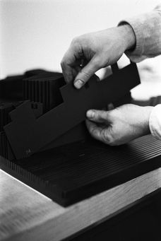
This model was presented along with the abstracted frontier model detailed above. The model was constructed as three intricate sections at 1/8" = 1'-0" scale which detail the most complex moments in my proposed architecture. These include the primary entry circulation and billboard facade, the depth/conclusion of the frontier at Jackson Square Park, and the upper workshop, gallery, and retaining wall which borders that chasm.
Constructed entirely of balsa wood and museum board, watercolor, gauche, and varnishes were utilized to detail the building's materiality and to indicate section cuts.

this model was built as three sections of the same building, placed on a plan of the same scale. this particular view demonstrates the use of the gansevoort hotel's billboard as a structural component of the upper volume.


These two pieces are bookmarked to display the dramatic depth of the frontier cut along 13th street, and the manner in which my architecture confronts or utilizes that boundary formally and programmatically.

this model was built as three sections of the same building, placed on a plan of the same scale. this particular view demonstrates the use of the gansevoort hotel's billboard as a structural component of the upper volume.
constructing space with light


